Monday, June 25, 2012

Georgetown Loop Railroad & Mt. Evans redux

Saturday was the warmest day of the summer so far so it was a good day to escape the heat by heading up to the mountains. Taking a ride on one of the old steam trains was definitely on my to-do list so after a short deliberation, the Georgetown Loop Railroad about an hour's drive away was an easy choice.

There were a lot of hummingbirds in Silver Plume, the starting point of the loop

After getting on the train, it didn't take long until we reached the Lebanon Silver Mine and took about an hour long tour both outside and in the mine. A very good guide explained a lot about how the actual mining was done and what it was like to be a miner in the 19th century. It didn't sound like that much fun to be honest. I haven't visited an such mine before so I found it really interesting.

An old photo of the Lebanon Tunnel entrance

Fast forward to 2012


After the mine tour it was time to continue towards Georgetown. The ride is actually really short and I have to say that I was a bit disappointed by it. I think it would've been jaw-droppingly amazing had I done this in the first week or two after arriving to Colorado but since I've seen so much of the Rockies already, it wasn't anything that special. It wasn't horrible by any stretch of imagination but it just didn't have the "wow factor".

Pic taken from on top of the high bridge


After having lunch in Georgetown, our plan was to head back and maybe check out Buffalo Bill's grave but we decided to check out Mt. Evans instead. I had been there three weeks prior with my parents but it was freezing back then and the day wasn't the best possible in other aspects either so I didn't mind getting back up there again.

I turned on the GPS at the Mt. Evans gate next to Echo Lake
Since it was a staggeringly hot day down in the foothills, it wasn't cold at all on the top either and it turned out to be a completely different experience from the last time. It took until the sunset (around 8.30 pm) until we got back home but it still was 96 F (35.5 C) down there!


Summit Lake wasn't frozen anymore


Chicago Lakes

These critters are really fast and taking a good picture of them can be really challenging

Haters gonna hate

The smoke from all the nearby forest fires really hurts the visibility

The Meyer-Womble Observatory is one the highest observatories in the world. The remains of the Crest House which burned down in 1979 can also be seen

Mountain goats are pretty chill creatures. Then again, with those pointy things on their heads, they can defend against pretty much anything


You shall not pass!


Sunday, June 24, 2012

More fire woes

Record high temperatures and no rain in sight is not good news. The High Park Fire is still out of control and dropped from 60% containment to just 45%. Currently, 81,190 acres (328 km2) are scorched and it still keeps spreading. It is, however, only one of nine large wildfires currently burning in Colorado. Yesterday, 21 homes were burned within the city limits of Estes Park and in Waldo Canyon west of Colorado Springs, over 2000 acres are currently up in flames with the number going up quickly.

The Drought Monitor shows extreme drought (in red) for large parts of the state
 That fire caused the mandatory evacuation of the whole town of Manitou Springs (population 5,000) which is right next to the Garden of the Gods which we visited back in February. It is also the starting point of the 9 mile cog railway to the top of Pikes Peak and the railway is naturally closed for at least today. Highway 24 (which we used to get to Pikes Peak just a few weeks ago) westbound out of Colorado Springs is also closed at the moment.

Webcam picture from the top of Pikes Peak showing the end point of the cog railway


Quite a contrast from these pics two weeks ago

Sunday, June 17, 2012

High Park Fire

This week there have been tornado warnings on the TV on many days and some areas have been in flash flood alert due to thunderstorms dumping great amounts of water in a short time. At first when arriving to Colorado I didn't really understand the phenomenon and seeing warning signs next to the canyon roads seemed very strange but flash floods can be extremely dangerous as e.g. this example from 1976 proves.


The big news, however, has been the High Park Fire which has been blazing for about a week now west of Fort Collins about an hour's drive to the north-northwest. It has continued to be incredibly dry and like with the last big fire in March, it got out of hand because of very high winds that spread it over too big an area to control. On Tuesday the wind blew the smoke right towards Denver and the visibility and the air quality was very poor. You could clearly smell it even inside the heavily air-conditioned office and all week firefighting airplanes and helicopters have been flying over the office to and from the nearby Broomfield airfield.

Some pics from the Huffington Post

The worst is now over but over 55,000 acres were scorched. That translates to 222 square kilometres and just to put that in perspective, that's more than the entire land area of the city of Helsinki. The fire killed one person and destroyed 181 homes (the most in Colorado's history) which might sound little compared to the massive area but it is sparsely populated due to its ruggedness and as much as 1500 firefighters have been battling day and night in order to protect more homes from going up in flames. One unlucky man who had lost his home commented on TV that all the people living in these remote locations have to accept the risk and that it's the price to pay for choosing to live in such a gorgeous setting.


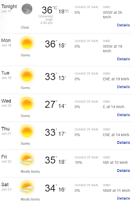
Looking at next week's weather forecast, it doesn't look any better and reports of other smaller fires are to be expected but fingers crossed that none of them get out of hand. Everyone in Colorado is hoping for some big showers and preferably ones that last for days rather than hours. We have had some local thunderstorms and although those might sound good at first, it's worth keeping in mind that this fire was actually started by a lightning strike so it's a bit of a catch-22. Just a side note: Vaisala's equipment was used for detecting the lightning strikes and you can get a quick glimpse of it in this news story around the 7:15 mark.

No help in sight next week

Saturday, June 9, 2012

Pikes Peak

When I first got the opportunity to come here to Colorado I did not know that much about the state apart from of course the Rockies, places like Denver and Aspen and that the TV-show South Park took place there. However, Pikes Peak was one of the places I had heard of and when I started planning for my to-do list, it was the first thing I listed. Weather permitting, it is kept open year round but it still took me over four months before I finally decided to take the trip.

Instead of heading straight to Colorado Springs via I-25, we decided to take a more scenic route through the mountains but the scenery was surprisingly dull and forest fires had burnt vast areas along the way. We did, however, pass through a place called Pine Grove where they had, believe it or not, the annual Rhubarb Festival. We Finns are used to strange events like swamp football and wife carrying competitions but a rhubarb festival is pretty high up there.

Pikes Peak as seen from Woodland Park where we had lunch

The road up Pikes Peak is in fantastic condition and nothing like the one up Mt. Evans which was a bit rough at places. It climbs almost two kilometres in 19 miles/30km to the top which is at 14,115 feet (4,302 m). Unlike with Mt. Evans, you can drive right to the very top which is flat and quite wide. The weather was on our side as it was an incredibly hot day and the temperature at the top was in the 50s in Fahrenheit, something like 11 C. It was somewhat windy as expected but nothing like on our trip to the top of Mt. Evans a few weeks back.


Colorado Springs has a population of over 400,000 but it doesn't look that impressive from up here


Wait, I thought that Santa lived up in the North Pole or in Korvatunturi, Finland and not at the foot of Pikes Peak
 

On the way back we took a bit of a detour to check out some petrified trees at the Florissant Fossil Beds National Monument
I think our original plan was to have lunch at the old mining town Cripple Creek but since we spent so much time on Pikes Peak, we ended up having lunch on the way there and just drove through the town. While looking at the map, one of my colleagues found a "shortcut" to Colorado Springs that he described as a road that looked like intestines. With a description like that, how could you now check it out? It turned out that it wasn't paved and very narrow in many points and because of the constant turns, you couldn't see very much ahead at all. The last five miles or so were also quite rough with huge potholes and bumps that made me quite happy that I wasn't driving the Chevy Cruze anymore.


This road used to be an old railroad and this tunnel is the only one that hasn't collapsed yet
There were a lot more cars coming the other way than in the clip below. It can be quite scary when you can barely see 20 metres in front of you and the road is so narrow that one of you has to give way to the other one.


Sunday, June 3, 2012

Trail Ridge Road

The Trail Ridge Road is "highest continuous paved road in the United States", continuous meaning that it just doesn't go somewhere and stop like is the case with the Mt. Evans road. The road is closed in winter and was opened only on the Memorial Day weekend in late May. This year Colorado has seen much less snow than usual and I think the road could've been opened much sooner but what can you do. This clip shows you just how much snow there was last year in June and what they have to do to clear the road.


My ride on Saturday. On Sunday we turned back in Grand Lake.

Me and some colleagues had agreed to go there on Sunday but on Saturday I was kind of bored and didn't know what to do so I went ahead and had a quick look-see. The entry fee is $20 per car but the year pass is $40 so I bought that instead since I will definitely be coming back after the unpaved Fall River Road is opened around the 4th of July.

The road starts from Estes Park and goes west to Grand Lake with the highest point being at 12,183 ft (3,713 m) which is well above the tree line. In the Rocky Mountain National Park you can see some cool wildlife from deer to marmots (closely related to groundhogs) to elk and even bighorn sheep although we didn't get that lucky.

Grand Lake, both the town and the actual lake. The lake is the largest natural lake in Colorado. All the larger ones are reservoirs.


The Continental Divide explained in layman's terms: pour some water on the left side of the plaque and it will eventually drain into the Atlantic Ocean or right side and it will end up in the Pacific Ocean


This is the most snow that we saw up there. Just goes to show how bad the drought in Colorado is at the moment when even the mountain tops are almost completely bare.


A marmot


I need a better camera. This looked so cool up there but the picture is anything but

Don't be shy now